Open Pit Mining
Every mine is unique and so should your monitoring plan. Each InSAR monitoring program is custom developed to fit the monitoring needs of our customers.
Complete the form to request product details, pricing, schedule a demo, or to discuss an upcoming project.
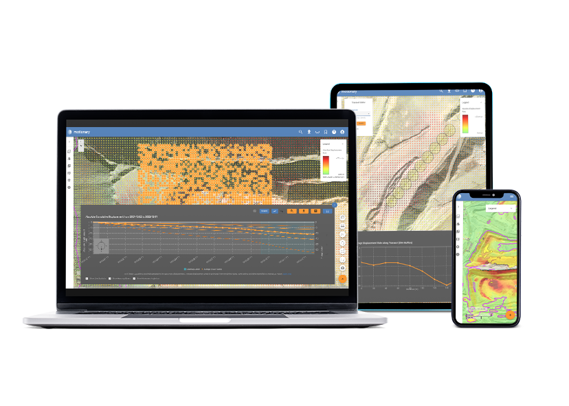
Motionary is 3vGeomatics’ web-based data delivery platform for easy data visualization of displacement information. Motionary provides access to results stored on the cloud, as well as tools for visualizing them in a GIS-like environment. Colour-coded points and raster information are superimposed on an optical image and an elevation model of choice. These can be viewed in 2D or 3D.
Displacement DataStream is a connected InSAR monitoring service that allows for near-real-time monitoring of critical assets without the barrier of data management. Motionary is 3vG’s web-based platform built to host the DataStream and provides simple and quick access to InSAR results stored on the cloud. The online tool alleviates requirements for software installation, licence keys, hardware requirements, and allows you to manage your own users. Access to Motionary is included at no cost for all Displacement DataStream subscribers.
Motionary’s toolset has been designed to maximise the benefit of the Displacement DataStream and all of its features. At first, when a user logs in, a raster heatmap is shown providing an overview of the project area. As the user zooms in, points are displayed showing the precise location of the displacement values. The toolset has been designed to manipulate and interpret vector and raster-based data such as:
All data delivered through Motionary is stored securely in the cloud, using Amazon Web Services (AWS). AWS sets the global standard in data storage and infrastructure security. Motionary utilizes the AWS platform, with industry-standard best practices, to ensure the highest level of security for customer data. All data is encrypted and stored using AWS Relational Database Service (RDS) on a private subnet, within a secure Virtual Private Cloud (VPC). Databases are backed up automatically and are deployed over multiple AWS availability zones to ensure near 100% uptime.
Our product team is dedicated to developing powerful data visualizations and tools that effectively communicate our analytical work. Through close collaboration with our clients, we develop, update, and refine our products to the specific needs of our clients. Based on each client’s needs, we can also develop custom products that address a sector-specific requirement.
Deliverables can include vector data usable in mapping software such as ArcGIS, QGIS, MapInfo or AutoCAD. Vector and raster displacement maps can be provided via secure FTP or through web mapping services (WMS) accessed through most GIS software packages. 3vG also supports integration into mining programs such as MAPTEK, Navstar/GeoExplorer, MineSight, and Canary. 3vG works with our clients to generate the products they need to easily and effectively leverage InSAR results in decision making. We have never found a platform we could not support.
We are very impressed with this data. We realized that we have problems right now in several areas caused by rain. We saw them shown in red on the map.”