Murray Down
27.01.2023
Complete the form to request product details, pricing, schedule a demo, or to discuss an upcoming project.

Interferometric Synthetic Aperture Radar (InSAR) is a powerful technology that uses satellite-based radar to remotely monitor ground displacement. However, terrain with thick vegetation or snow cover can cause problems for its readings. Specialized L-band InSAR satellites use longer wavelengths to measure ground displacement through vegetation, but their displacement measurements are less precise than other InSAR satellites using the more common short wavelengths. For terrain covered by heavy snow, InSAR monitoring must be suspended during winter months, but good quality measurements before and after the snow cover period can be used to span the winter gap.
Interferometric Synthetic Aperture Radar (InSAR) is a powerful technology that uses satellite-based radar to remotely monitor ground displacement. Compared with on-the-ground methods, InSAR offers labour cost savings and allows wide-area monitoring of inaccessible locations. Another important benefit for InSAR is its coverage. Traditional in-situ ground instrumentation can only monitor where the equipment is placed—so, maybe hundreds of points. Meanwhile, InSAR can measure hundreds of millions of points with comparable precision.
This post will examine some of the considerations when using InSAR to monitor difficult terrain, including vegetation and snow.
The short wavelengths used by most InSAR satellites have difficulty penetrating dense vegetation. 3vG characterizes the levels of vegetation as low, medium, and high. Low vegetation, like desert or sparse grass-land, for example, poses no issue for InSAR. Medium vegetation, like a long-grass prairie, can be measured with an intermediate wavelength, like C-Band.
High density vegetation—like the British Columbian rainforest—can only be monitored by longer, L-band wavelengths.
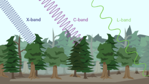
X-band, and C-band wavelengths are much shorter, roughly 31 mm and 56 mm respectively. A shorter wavelength translates into higher measurement precision on the ground. In good conditions, InSAR is capable of detecting displacement along the satellite’s line-of-site as small as ~2 mm using X-band, or ~4 mm using C-band. By comparison, the L-band wavelength is closer to 240 mm, which reduces the measurement precision to ~20 mm. However, ground conditions and the number of images used for processing are also factors in measurement precision. It’s important to emphasize that these displacement measurements are averaged out over the pixel size, which also varies between satellite options, typically in the range of 1 m to 10 m. For example, an X-band satellite in the most common mode with 3 m pixel spacing can measure the average displacement of the ground within each 3 m wide pixel area with a precision of ~ 2 mm along the satellite’s line of sight. It combines millions of these pixel measurements to make the displacement rate map of a large area.
Satellites capable of using L-band wavelengths are less available than those that use standard-wavelengths. Currently, there are only two options for ground monitoring with L-band InSAR: SAOCOM and ALOS-2 (successor to ALOS).
SAOCOM is an Argentine satellite constellation for commercial operations launched in 2020. It produces data with a spatial resolution of 10 meters with images available every eight days.
ALOS-2 is a Japanese satellite. 3vG has been using it successfully since 2015 to monitor conditions from North American boreal forests to tropical Indonesian jungles, over areas as large as 178,500 square kilometres. Measurements from ALOS-2 have a spatial resolution between three and ten meters, with images available once or twice a month depending on available satellite time.
Snowy ground conditions can be even more difficult for InSAR readings than vegetation. The best practices for monitoring snowy areas with InSAR depend on the amount and frequency of snowfall.
In areas with high levels of ground displacement and minimal snow cover, InSAR can distinguish between true displacement and the background noise created by the snow with only a small loss of accuracy and precision. Sites with only light, sporadic snowfall can often be monitored as normal, keeping in mind that not all readings may be of identical quality.
In areas with heavier snowfall, InSAR readings can be reduced to pure noise. For areas with heavy months-long snow cover, InSAR readings are typically paused during the winter months. However, advanced processing algorithms can often span the winter gap by measuring differences between the late fall data and the early spring data to provide results in the spring that show the magnitude of displacement that occurred over the winter.
The advantages of InSAR ground displacement monitoring are immense for sites whose size or remoteness makes on-the-ground measurements impractical.
To get the most use out of InSAR technology, its limitations must also be considered. This means using the most appropriate satellite technology for the terrain. Generally, X-band satellites will get the most precise readings from open ground, but densely vegetated areas require specialized L-band InSAR satellites.
Efficient InSAR use also takes seasonal obstacles into account, reducing, or suspending readings during times of heavy snow cover.
When the characteristics of a site’s terrain are considered, InSAR allows ground displacement monitoring at scales that would be otherwise impractical or impossible.